Urban? Rural? Why does the distinction matter?
The idea of what constitutes a rural community is undergoing change across the Toronto region as new housing subdivisions redefine what it means to be “rural.”
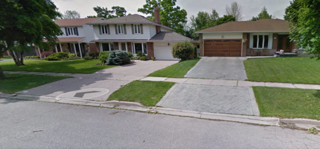
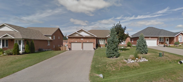
Sometimes new development in rural communities is indistinguishable from a suburban subdivision in an urbanized municipality, as we see in the image below. The one on the top is a subdivision in suburban Mississauga; the one below is in the rural community of Everett.
- Urban Mississauga, ON. Urban (Photo: Google Earth)
The distinction matters because under the Growth Plan for the Greater Golden Horseshoe (the provincial plan to curb sprawl), different rules are supposed to govern what can be built where, depending on the urban/rural designation.
In the Geoweb, the criterion for identifying a community as urban is whether it has what the Province calls a “Built Boundary.” The Province measured the extent of urbanization in 2006; it drew a boundary around any community considered “urban” to distinguish intensification (development inside the boundary) from greenfield development (development outside). Different rules apply to the two kinds of development.
According to the Province, “A precise boundary is delineated for those settlement areas, identified in consultation with municipalities, that have full municipal services [watermains and sewage systems], will be a focus for intensification, or will accommodate significant future growth” (Built Boundary for the Growth Plan for the Greater Golden Horseshoe, page 25).
The Province considers any other settlement an “undelineated built-up area.” These are “smaller, unserved, or partially-serviced settlement areas, which have limited capacity to accommodate significant future growth…typically small towns and hamlets." Under the Growth Plan, “where a settlement area does not have a built boundary, the entire settlement is considered Designated Greenfield Area.”
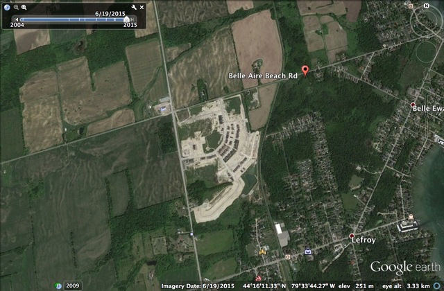
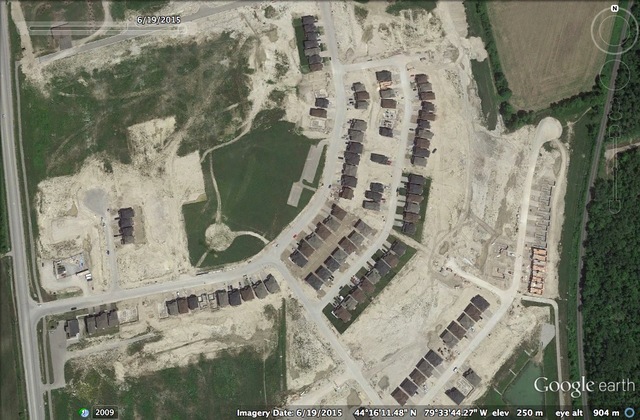
Despite the wording in the Growth Plan that rural communities will not be a focus for growth, a few have been allowed to designate land for expansion. The most sizable of these is Snow Valley in Simcoe County, just north of Barrie and west of Midhurst (both of which are growing urban settlements.)
Further complicating the issue is the fact that in some cases, local official plans identify some villages and hamlets as “urban settlements.” Such is the case with the communities of Sandy Cove and Lefroy in Innisfil, Simcoe County.
Under the Growth Plan, the province did not assign a built boundary to either community – so in the Geoweb, they are defined as rural settlements.
Simcoe County, the upper-tier level of government, identifies both communities simply as “settlement areas” in its official plan and makes no distinction between urban and rural.
However, Innisfil, the lower-tier level of government, identifies Lefroy as a “growth centre”; a secondary plan was completed for the town in 2007 and approved by the Ontario Municipal Board in 2009 and 2010. Three landowners have put forward a subdivision plan for 1,550 homes on 257 acres. Lefroy does not have full municipal servicing yet, although the Innisfil official plan notes that there are plans for servicing in the future.
What is rural and what is urban matters, because the amount of land designated as rural settlement is not inconsiderable – especially in the Outer Ring beyond the Greenbelt. In the Outer Ring, rural settlement areas represent almost 20% of the settlement land area, while in the Inner Ring they represent less than 5%.
In other words, one out of every five hectares of land designated for settlement uses in the Outer Ring is part of a rural community that does not offer transportation alternatives to the private automobile or well-developed water, sewer, and other infrastructure. Yet the Growth Plan was created to address the mismatch between infrastructure and new development and “direct growth to built-up areas where the capacity exists to accommodate the expected population and employment growth” (Growth Plan, Section 1.1).
Are these communities urban or rural? It depends on which level of government you ask. But how does the expansion of unserviced rural communities contribute to the goals of the Growth Plan?


Comments